Tracking Outer Tropical Cyclone Rainband (Yu et al. 2019)
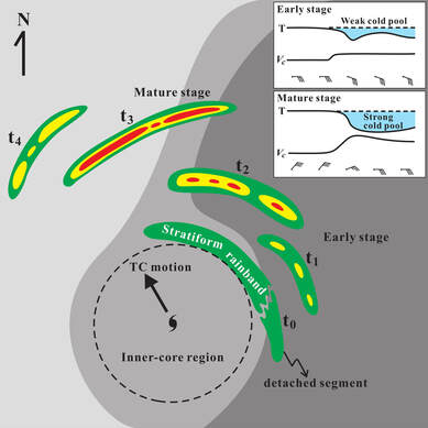
Tropical cyclone rainbands (TCRs) are the most striking and persistent feature of tropical cyclones (TCs). Torrential rainfall associated with TCRs is one of the major causes for the occurrence of extreme floods as TCs approach or encounter landmass and has a wide variety of significant impacts on the earth system and society. TCRs are traditionally classified into inner and outer rainbands based on the degree to which convection is influenced by the inner-core vortex circulation. In contrast to a better understanding of the inner TCRs, the initiation and development of outer TCRs remain largely unexplored and controversial. This article improves our understanding on the origin and evolution of outer TCRs by using a combination of Taiwan and Japan Doppler radar and surface observations to track the history of an outer TCR from its formative to mature stage. This research work not only presents a detailed and insightful analysis of a squall-line-like outer rainband but also provides a generally clear and insightful contribution to the field.
|
Ocean Observations of Tropical and Extratropical Cyclones (Domingues et al. 2019)
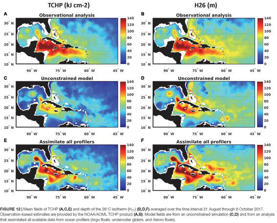
Over the past decade, measurements from the climate-oriented ocean observing system have been key to advancing the understanding of extreme weather events that originate and intensify over the ocean, such as tropical cyclones (TCs) and extratropical bomb cyclones (ECs). In order to foster further advancements to predict and better understand these extreme weather events, a need for a dedicated observing system component specifically to support studies and forecasts of TCs and ECs has been identified, but such a system has not yet been implemented. New technologies, pilot networks, targeted deployments of instruments, and state-of-the art coupled numerical models have enabled advances in research and forecast capabilities and illustrate a potential framework for future development. Here, applications and key results made possible by the different ocean observing efforts in support of studies and forecasts of TCs and ECs, as well as recent advances in observing technologies and strategies are reviewed. Then a vision and specific recommendations for the next decade are discussed.
|
Figure caption: Mean fields of tropical cyclone heat potential (TCHP A, C, E) and depth of the 26℃ isotherm (H26) (B, D, F) averaged over the time interval 21 August through 8 October 2017. Observation-based estimates are provided by the NOAA/AOML TCHP product (A, B). Model fields are from an unconstrained simulation (C, D) and from an analysis that assimilated all available data from ocean profilers (Argo floats, underwater gliders, and Alamo floats).
|
Rapid Intensification (Lee and Wu 2018)
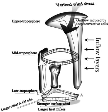
High-resolution numerical experiments for Typhoon Megi (2010) in the western North Pacific are conducted using the Advanced Research version of the Weather Research and Forecasting (WRF) Model to understand the mechanisms of rapid intensification (RI). With a dynamically initialized vortex, sensitivity experiments are carried out focusing on the planetary boundary layer (PBL) and the following microphysics schemes: WRF single-moment 6-class (WSM6) and WRF double-moment 6-class(WDM6) microphysics with Yonsei University, Mellor–Yamada–Janjić (MYJ), and Mellor–Yamada–Nakanishi–Niino (MYNN) 2.5-level (MN2.5) and 3.0-level (MN3) PBL schemes. The largest differences are found between WSM6-MN3 and WDM6-MN3, and we therefore examine RI mechanisms based on the results of these experiments. Prior to RI, WDM6-MN3 shows a drier environment and stronger downdrafts in the lower troposphere than in WSM6-MN3. As a result, during the RI period, WSM6-MN3 (WDM6-MN3) significantly intensifies with the minimum sea level pressure decreasing by 51 (29) hPa and the maximum surface wind increasing by 28 (12) ms-1 in 24 h. In both experiments, the maximum values of surface heat fluxes, potential vorticity (PV), radial absolute angular momentum advection, inertial stability, supergradient wind, and convective bursts inside the radius of maximum winds are frequently observed at each vertex of polygonal eyewalls in the lower troposphere. In particular, WSM6-MN3 exhibits more convective cells inside the inner-core region, a more persistent and thicker polygonal eyewall in the lower troposphere, and a more robust vertical structure of hydrometeors and vertical velocity than WDM6-MN3. This study suggests that within the inner-core region, polygonal eyewalls like WSM6-MN3 provide favorable conditions for RI.
|
Figure caption: A schematic illustration of the possible RI mechanism in the polygonal eyewall structure. At each vertex of polygonal eyewalls denoted by capital letters A–C, stronger surface wind and convection, larger radial AAM advection, and surface heat fluxes are well observed. Based on the present results, the strongest supergradient wind is found around B. This schematic illustration can be compared with Houze (2010, their Fig. 24).
|
THE DEGREE OF PREVALENCE OF SIMILARITY BETWEEN OUTER TROPICAL CYCLONE RAINBANDS AND SQUALL LINES (YU ET AL. 2018)
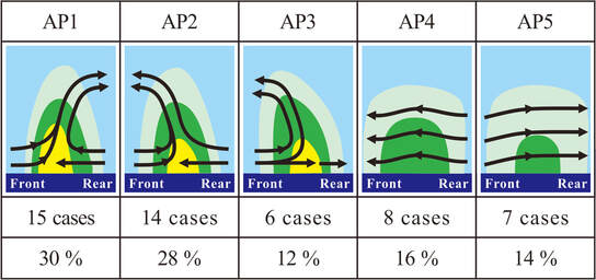
TCRs have been traditionally considered as manifestations of atmospheric waves initiated near the eyewall or close to the TC center. In this context, the convective initiation and development of TCRs are primarily govern by wave-induced disturbances and have been usually thought to be distinctly different from those of ordinary convective rainbands such as squall lines. This long-standing, traditional belief has been shaken lately by the limited research evidence showing the possibility for TCRs to develop squall-line-like characteristics in the outer environment of TCs. However, whether this appealing similarity emerges as a common or exceptional case has not been identified nowadays because only very few outer TCRs have been thoroughly studied and reported in the literature. In this study, the degree of the prevalence for this similarity is explored by radar and surface observations from a large set of 50 outer TCRs associated with 22 TCs as they approached Taiwan. The results indicate that around 58% of outer TCRs are similar to squall lines. These outer TCRs are generally characterized by convective precipitation, an obvious convergence zone between the band-relative rear-to-front flow and front-to-rear flow at low levels, either frontward or rearward tilting updrafts, and a surface cold pool signature. The frequent similarity between the outer TCRs and squall lines documented in this study provides important insights into the formation of organized, heavy precipitation associated with TCs.
|
Figure caption: Schematic band-normal vertical cross sections qualitatively illustrating the band-relative kinematic structures and their associated precipitation for five different airflow patterns (APs) identified from the studied TCRs. Heavy solid arrows indicate salient airflow features observed from the dual-Doppler analyses, and color shading denotes the generalized precipitation pattern associated with the studied TCRs. The number of the TCR cases and frequencies of occurrence for each AP are also indicated.
|


